Changing Coastlines
Rising sea levels and increased frequency and severity of extreme weather events due to climate change, damage coastal buildings, infrastructures, and beaches, impacting municipalities, First Nations, and Provincial and Federal governments. In order to implement mitigation and adaptation strategies, Natural Resources Canada has provided generous support to the Changing Coastlines project to develop a layered approach to coastal adaptation that incorporates living systems and enhances local and regional ecosystems and spatial quality while reducing flood/erosion risks and vulnerabilities caused by sea level rise.
Canada’s coastline is the largest in the world measuring 243,042 km. In western Canada, in coastal cities such as Vancouver, municipal and city governments have already begun to utilize adaptation strategies to protect and enhance coastal ecosystems, and existing coastal infrastructure. These strategies include a suite of hard and soft conventional and unconventional approaches that are meant to reduce risk related to sea level rise (SLR) by integrating coastal ecosystem adaptive capacity with nature-based ecosystem, and governance solutions
Interactive features
This project is meant to be a resource for planners, designers, and coastal managers in the Fraser River Delta as well as audiences globally. It provides different resources in the form of interactive maps, narrative sections, and visualizations of a wide range of flood adaptation approaches that incorporates strategies for coastal environmental design based on the idea of designing with nature. It is our hope that these resources help audiences better understand the spatial challenges and potential strategies to tackle coastal flood adaptation.
Why Coastal Adaptation?
Sea level rise (SLR) is one of the most existential challenges facing contemporary societies. According to the United Nations, over 40% of the world’s population live within 100 km of coastlines, and three-quarters of all major cities are located in deltas and coastal areas. Researches have projected that increased global temperature can result in rising sea levels ranging from 60cm to 2m by the end of the century. In addition to SLR and other effects of climate change, coastal areas are also confronted with the challenge of ongoing population growth, aging infrastructure, and declines in coastal social and ecological systems occasioned by interruptions in coastal geomorphological processes. Imagining alternative futures for coastal cities will require coastal planning strategies that are focused on the opportunities for adaptation to changes affecting coastal systems using environmentally sensitive design and engineered solutions that promote more resilient coastal urban landscapes. Approached in this way, coastal adaptation can become a mechanism to develop novel planning and design approaches to revive ecosystems, to produce sustainable food and energy systems that recycle waste and nutrients, and promote beneficial exchanges between social and biophysical processes.
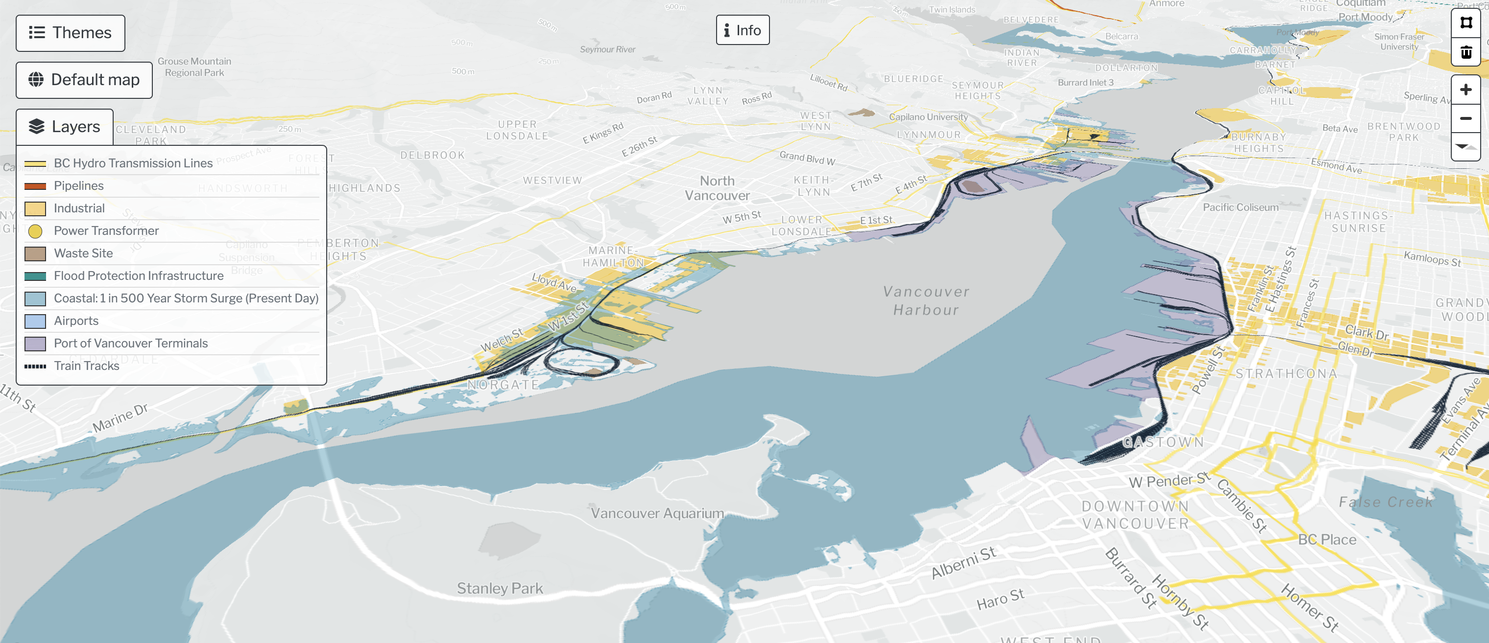
Flood Risks in the Fraser River Delta
Like many deltas in the world, the Fraser River Delta (FRD) faces a range of environmental and engineering challenges concerning flood management. Situated along the Pacific Flyway, the FRD is home to a rapidly growing population of nearly 3 million people and the largest port on the west coast of North America. Given the realities of climate change, SLR, and the increasing incidence of flooding, flood management will become increasingly important in the future. Responding to SLR will require the development of a suite of adaptation strategies that promote safe, healthy, and regenerative futures for all forms of life in the region. The following section provides a high-level overview of several key coastal impacts and adaptation challenges in the region.
Outdated Flood Control Infrastructure
In 2011, a report by B.C.’s Ministry of Forests, Lands and Natural Resource Operations entitled Cost of Adaptation – Sea Dikes and Alternative Strategies, made headlines in local and national media (Figure 1). The report estimated that it will require nearly $9.5 billion to update and reinforce the 250km of dikes in the Lower Mainland to protect the region against the implications of climate change and SLR. Most of these existing dikes have been built or upgraded to meet design guidelines set in 1969, but these standards do not take into consideration the effects of climate change, subsidence, seismic activity, and SLR. Only 4% of all dikes along the Fraser River are high enough to withstand the “flood level design” which were derived from the record flood in 1894. Over 70% of dikes would be overtopped if a similar event would happen today.
At the same time, the geology and geomorphology of the Fraser River Delta combined with the region’s proximity to the Cascadia fault line, make it technically challenging and relatively expensive to implement protection measures. As such, more detailed coastal modeling as well as case studies of various adaptation options are necessary on both site-specific and regional scales, before long-term management strategies can be tested and developed for each of the shorelines in the region. This approach would ensure that adaptation solutions are both feasible and cost-effective.
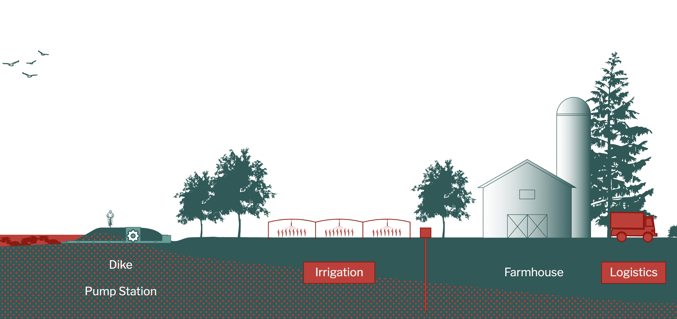
Urban Development Pressures
People have lived in, and engaged with, the Fraser River Delta for over 10,000 years. During most of this period, hunting, harvesting, and gathering of resources had no far-reaching effects on the form and functioning of the delta. However, over the past two centuries, population growth and urban development have significantly transformed the delta, both spatially and ecologically.
Pressures to keep urban development out of the floodplain have been an ongoing concern. The Lower Mainland Official Regional Plan, which was adopted in 1966, explicitly called for “Floodplains to be kept free of urban uses except where such areas are committed to urban development through early settlement, in which case further development for urban uses shall be contingent upon flood proofing.” Similar pronouncements can be found in successive regional planning documents. Yet, over the past several decades, development within the floodplain has proliferated across the region. As a result, over 250,000 people in the region now live within about a meter of mean sea level.
With regional population growth of approximately 35,000 residents per year, pressure to develop in flood-prone areas will continue to be a significant challenge in the future. Adopting land-use policies, that take into consideration flood construction levels, and envisioning new ways in which urban developments can occur within flood management and SLR thresholds will be critical for the long-term livelihood of residents in the region.
Legislation and Decision-making
In British Columbia, the responsibility for flood-risk management lies with municipalities and other local government authorities. This means that municipalities are expected to plan and implement guidelines and mandates that are designed to promote flood-risk management. Currently, however, municipalities do not have sufficient resources (human and financial) to manage and implement flood control measures that meet the provincial guidelines. Additionally, the permitting process tends to reinforce implementation of conventional hard infrastructure strategies (such as dikes, seawalls, and breakwaters), while there is a growing interest and demand for the development of alternative adaptation approaches, including nature-based solutions.
Moreover, there is limited coordination and resource allocations between municipalities in terms of understanding and managing upstream causes and downstream effects of flooding. Currently, the Fraser Basin Council, FBC a non-profit entity, is the only organization actively bringing municipalities across the region together to share data, to identify risks and vulnerabilities, and to develop a long-term regional flood strategy. Since SLR does not know any boundaries, it will be important to further develop governance arrangements through which all relevant rightsholders and stakeholders can work together to co-create near and long-term coastal adaptation strategies for SLR and flood management across a range of scales.