Adaptation Strategy: Scour Protection
Scours are property-specific structural tools that are used to protect shoreline structures or building foundations from exposure to the corrosive effects of moving water. Scour protection is typically constructed from riprap or other types of material. The material is applied around the foundation of a structure to prevent erosion from wave action.1 Scours are commonly used in protecting the bases of bridge foundations, seawalls, coastlines near highways, rails, or pipelines.2 The strategy has limited protection as it only minimizes risk directly to the foundation of buildings and structures.3
Types of scour protection
- A spur dike is an elongated structure with one end on a bank of a stream and the other end projecting into the water. Spur dikes have been used widely for the protection of stream banks against erosion. They have also been used for the enhancement of aquatic habitats by creating stable pools in disturbed unstable streams. 10
- A debris basin consists of an earth dam and a barrier constructed across a drainage way or other suitable location to collect sediment. Excess runoff from the dam occurs through spillways. Small pools of water flow through a sediment basin which captures and discharges runoff from adjacent lands. This allows larger silt particles to drop out into the pool. 11
- Check dams also referred to as ditch checks, dikes, and wattles, may be temporary or permanent linear structures that are installed in a perpendicular position to the flows emanating from drainage ditches, channels, and swales. Check dams help to reduce flow velocity and prevent the down-cutting of channels 12
- Longitudinal stone toe is an alternative form of a windrow revetment where stones are placed along the existing streambed rather than on top of a bank. “The longitudinal stone toe is laced with a crown well below the top bank, either against the eroding bank line or a distance riverward of the high bank.” 13
Benefits
- Longitudinal stones help to preserve significant amounts of the existing vegetation on a bank slope. It also encourages the growth of additional vegetation when the bank slope is stabilized. 14
- The cost of protecting local scours is low. The maintenance requirements are also low. Additionally, local scours are relatively easy to construct and adjust to minor scouring. 15
- Check dams help to promote infiltration which results in a reduction in channel erosion. Check dams also serve as traps for coarse sediments. 17
- Check dams can reduce peak stormwater runoff.
- Scour protection with lower levels of invert can improve discharge and reduce flooding levels.
Challenges
- Longitudinal stone toe protection only provides toe protection. It does not directly protect the mid and upper banks. Some erosion of the mid and upper bank areas may occur during long-duration, high energy flows, particularly, before these areas stabilize and become vegetated. 14
- Local scours may be destabilized by a moderate flood before vegetation is re-established. 15
- Spur dikes can lead to the contraction of the flow path which subsequently increases flow velocity in the contracted section. 16
- Check dams can lead to a reduction in channel conveyance capacity thereby increasing the probability of overtopping. 17
Example projects
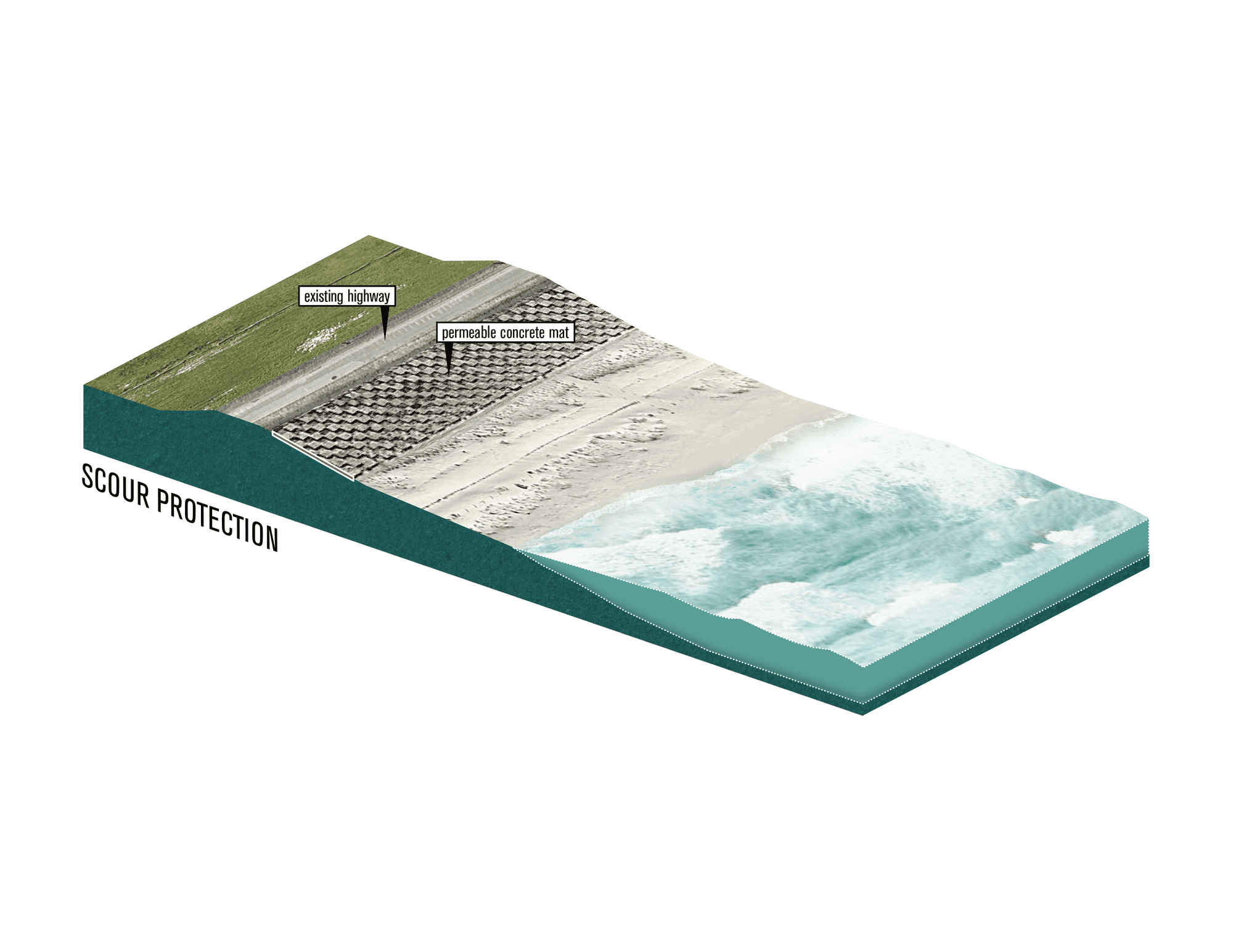
Gulf of Mexico Wave Protection
Franklin County FL, USA
Along State Route 30/US 98 Coastline, beach erosion has been a major problem for more than 30 years.4 The highway is adjacent to the coastline and coastal erosion continues to destabilize the roadway. In response, the County decided to construct a revetment system along the coastline using a Contech ArmorFlex revetment system.5 The ArmorFlex revetment system features interlocking blocks with a high unit weight that can withstand wave action and a porous system that promotes vegetation and habitat enhancement.6
Shubenacadie River
Shubenacadie NS, Canada
During the 1980s and 1990s, the Nova Scotia Department of Agriculture and the Nova Scotia Department of Environment implemented several stream bank protection projects along the Shubenacadie River to mitigate the impacts of erosion on water quality and marine habitat.7 Gabion baskets and mats were used in the stabilization of the river bank to protect the adjacent road.8 Other transportation infrastructures such as the Cheticamp Bridge that spans across the Shubenacadie River are also protected using similar gabion mats to protect the foundations of the bridge from erosion.9
Citations
-
1.
↑
The Arlington Group Planning Architecture Inc., et al. Sea Level Rise Adaptation Primer. pp. 61. https://www2.gov.bc.ca/assets/gov/environment/climate-change/adaptation/resources/slr-primer.pdf
-
2.
↑
Ibid, 61.
-
3.
↑
Ibid, 62.
-
4.
↑
“Gulf of Mexico Wave Protection.” Contech Engineered Solutions, https://www.conteches.com/knowledge-center/case-studies/details/slug/gulf-of-mexico-wave-protection.
-
5.
↑
Ibid.
-
6.
↑
Ibid.
-
7.
↑
Brenton, Paul, and John McCabe. Stream Bank Protection Project. Nov. 2013, pp. 2. http://www.nsfa-fane.ca/efp/wp-content/uploads/2018/08/stream-bank-protection-final-report.pdf.
-
8.
↑
Ibid, 4.
-
9.
↑
Leys, Vincent, and Daniel Bryce. Adapting to Climate Change in Coastal Communities of the Atlantic Provinces, Canada: Land Use Planning and Engineering and Natural Approaches. Mar. 2016, pp. 27. https://research.fit.edu/media/site-specific/researchfitedu/coast-climate-adaptation-library/canada-amp-arctic/canada---atlantic/Leys--Bryce.--2016.--CC-in-Coastal-Communities-of-the-Atlantic-Provinces,-Land-Use,-Engineering-Natural-Approaches.pdf.
-
10.
↑
Kuhnle, R. (2020). USDA. Watershed Physical Processes Research: Oxford, MS. https://www.ars.usda.gov/southeast-area/oxford-ms/national-sedimentation-laboratory/watershed-physical-processes-research/docs/local-scour-in-the-vicinity-of-spur-dikes/#:~:text=A%20spur%20dike%20can%20be,pools%20in%20unstable%2C%20disturbed%20streams.
-
11.
↑
Steichen, J. (2020). Design Criteria for Debris Basins. https://extension.missouri.edu/publications/g1528
-
12.
↑
Minnesota Pollution Control Agency. (2019). Sediment control practices - Check dams (ditch checks, ditch dikes). https://stormwater.pca.state.mn.us/index.php/Sediment_control_practices_-_Check_dams_(ditchttps://www.nrcs.usda.gov/wps/PA_NRCSConsumption/download?cid=nrcseprd526807&ext=pdfh_checks,_ditch_dikes)
-
13.
↑
Biedenharn, D. S., Elliott, C. M. and Watson, C. C. (1997). THE WES STREAM INVESTIGATION AND STREAMBANK STABILIZATION HANDBOOK. https://www.nrcs.usda.gov/wps/PA_NRCSConsumption/download?cid=nrcseprd526807&ext=pdf
-
14.
↑
Canilho, H., & Fael, C. (2018). Velocity Field Analysis of a Channel Narrowed by Spur-dikes to Maximize Power Output of In-stream Turbines. Journal of Sustainable Development of Energy, Water and Environment Systems, 6(3), 534-546. https://agupubs.onlinelibrary.wiley.com/doi/full/10.1029/2007WR006489
-
15.
↑
Burcharth, H. F., Zanuttigh, B., Andersen, T. L., Lara, J. L., Steendam, G. J., Ruol, P., ... & Nørgaard, J. Q. H. (2015). Innovative engineering solutions and best practices to mitigate coastal risk. In Coastal risk management in a changing climate (pp. 55-170). Butterworth-Heinemann. https://www.sciencedirect.com/topics/engineering/local-scour
-
16.
↑
Giglou, A. N., Mccorquodale, J. A., & Solari, L. (2018). Numerical study on the effect of the spur dikes on sedimentation pattern. Ain Shams Engineering Journal, 9(4), 2057-2066.
-
17.
↑
TRPA BMP Handbook (2014). Check dams. https://www.tahoebmp.org/Documents/BMPHandbook/Chapter%204/4.3/k_ChckDam.pdf
-
i1.
↑
Figure 1. Envirostruct Services. (2020). Scour Protection. http://estruct.com.au/waterways/revetment-walls/scour-protection/
-
i2.
↑
Figure 2. “Gulf of Mexico Wave Protection.” Contech Engineered Solutions, https://www.conteches.com/knowledge-center/case-studies/details/slug/gulf-of-mexico-wave-protection.